Charting every ferry in the Salish Sea · Ivan · @ivanoats
A bike-and-ferry loop
Seattle → Bainbridge →(bike) Kingston → Edmonds
Whose boats? Which docks? What are all my options?
The answer today
23 operators. 23 websites.
The border problem
Every map stops at the border.
49°N
The last border dispute out here was about a pig. San Juan Island, 1859.
Officially, since 2009–2010
Puget Sound+Strait of Georgia+Strait of Juan de Fuca
= the Salish Sea
Background: Map of the Salish Sea & Surrounding Basin, Stefan Freelan, WWU, 2009 · stefanfreelan.com/salishsea
So I counted
59routes
23operators
101terminals
1map
From the 90-minute Coho to the 5-minute summer hop to Jetty Island.
salishseaferrymap.com
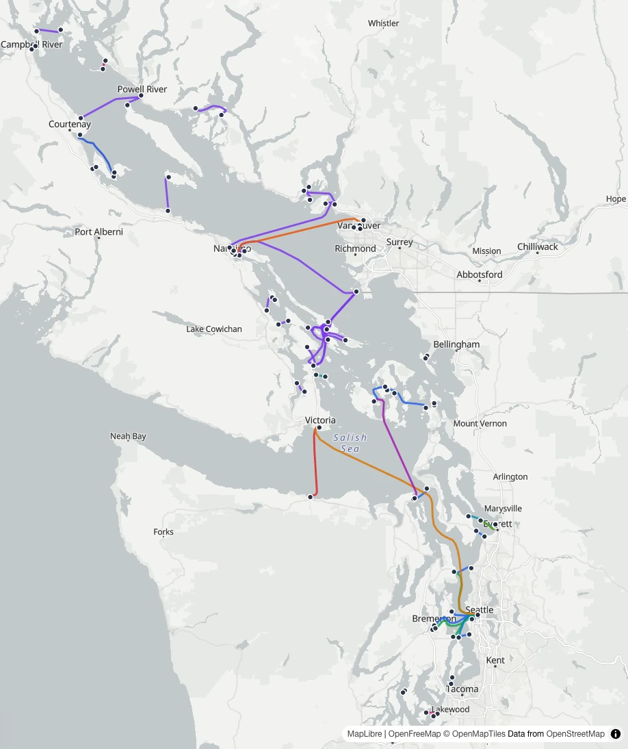
Every route, every operator.
BC Ferries · 23
WSF · 9
Kitsap Transit · 5
King County Water Taxi · 2
False Creek Ferries · 2
18 more, one route each
The live site, light mode. Suspended routes hidden by default.
The stack
All open, all boring (good).
MapLibre GLrendering
OpenStreetMapbasemaps and route geometry
GeoJSONthe routes
Next.js + TypeScriptthe wrapper, on Netlify
The data
Hand-curated. Checked against GTFS.
Some operators publish no feed at all. Where feeds exist, they're pinned and used at build time to check the data, not replace it.
Terminal audit against OSM
17 terminals were in the water.
up to 850 moff their docks
OSM node IDsnow cited in a comment on each one
Precision
Dock-level. Not survey-grade.
Not for navigation
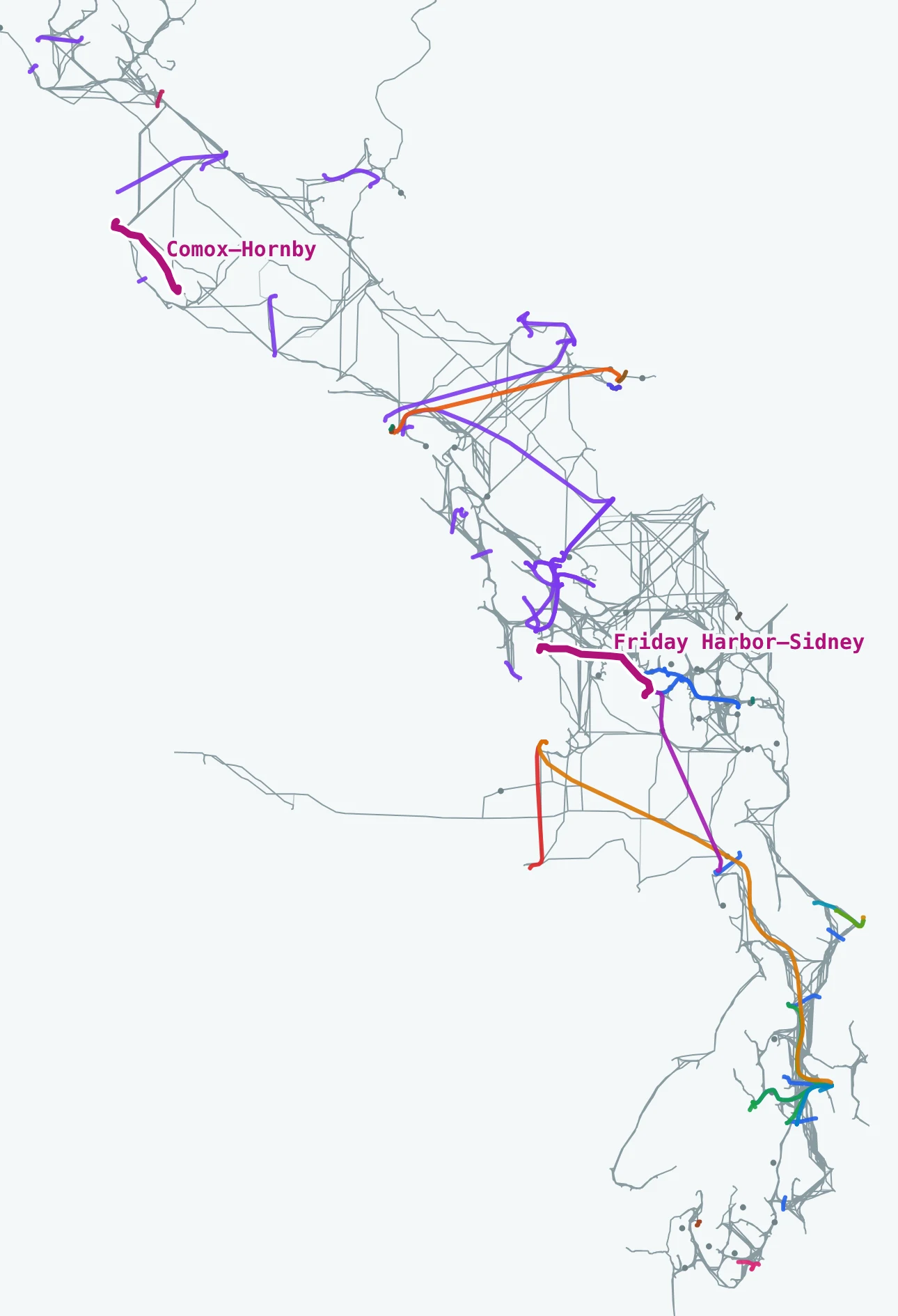
Lines over water
OSM where it's mapped. The mesh where it isn't.
85OSM ferry routes
2water mesh
0straight lines
Grey: the navigable-water mesh from salish-nav-planner, built from OSM's coastline. Color: OSM ferry routes. Magenta: the two legs only the mesh can draw.
How · scripts/build-route-geometry.ts (condensed)
A fallback chain.
const osm = osmRouteCoordinates(osmGraphs, from, to);
if (osm !== null) {
  geometry.set(key, { source: "osm", coordinates: osm });
  continue;
}

const mesh = meshPathCoordinates(waterMesh, from, to);
if (mesh !== null) {
  geometry.set(key, { source: "mesh", coordinates: mesh });
  continue;
}

// last resort, and the count on the last slide was zero
geometry.set(key, { source: "straight", coordinates: [from, to] });
Baked at build time. Neither dataset ships to the browser.
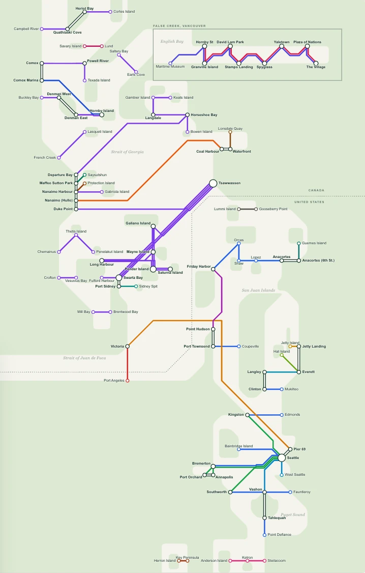
A second view · /schematic
A Beck-style route diagram.
Every leg at 45°. Terminals placed by hand. Shared corridors run in parallel lanes, like the Tube map.
Geography in, diagram out
Placed by hand. Checked by code.
Terminals sit on hand-picked grid points. Code works out the parallel lanes, and the build fails if a line leaves the 45° grid or crosses land.
Diagram: every leg at 0°, 45° or 90°
Print
A web map is not a print map.
Teewhole diagram · 3600 × 4800 px at 300 DPI
Totecropped to Puget Sound, or the labels print at 4 pt
The live layer
Real boats, right now.
WSDOTVessel Locations API
→
server proxykeeps the key private
→
vessel dotson the map
No API key? The layer turns off and the map still works.
Scope
A route map, not a trip planner.
No schedules. No fares. On purpose. The operators already publish those, and they change constantly.
Help wanted
Know a dock better than OSM does?
Check the terminal you know best
Tell me about a boat I've missed
Help build the bridge layer: six crossings with no ferry
One sea, connected by boats
Thanks, CUGOS.
salishseaferrymap.com
github.com/ivanoats/Salish-Sea-Ferry-Map
PRs welcome · find me after
Title illustration inspired by the design elements of Coast Salish art: circle, crescent, extended crescent and trigon. Slide 5 map: Stefan Freelan, WWU, 2009.